AI-based predictive wildlife detection for the French national railroad SNCF
Project 2023 – 2025
The goal of this research project, conducted at FHNW in collaboration with SNCF Réseau, is to use artificial intelligence (AI) and an integration of multimodal data (multispectral satellite time series, aerial imagery, agricultural and climatological information, and data from terrestrial sensors) to model the probabilities of wildlife presence near the track infrastructure of the SNCF network.
The resulting predictive habitat models will help to better prevent incidents, for example by taking appropriate structural measures in certain risk areas.
This Big Data project will use the latest machine learning technologies to process the extremely large and challenging data sources and make profitable correlations from the processing.
The project is based on the long-standing and recognized experience of the Institute of Geomatics of the FHNW in AI-based approaches for detection, classification tasks and modeling in the field of spatially and temporally referenced, complete geodata.
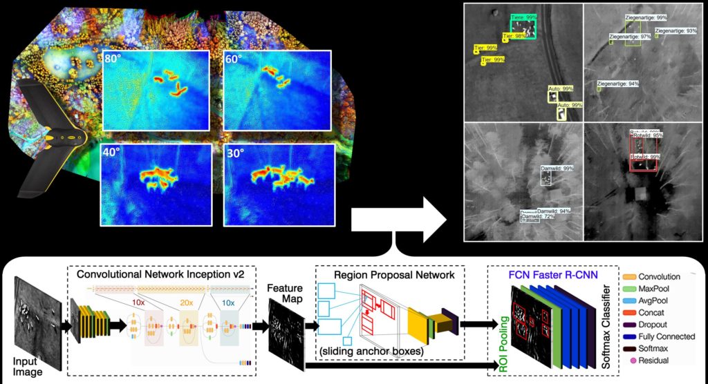
Wildlife such as deer and other mammals can be detected using drone based aerial imagery and artificial intelligence
Project 2019 – 2021
For applications such as population detection, fawn rescue and wildlife damage prevention in disciplines such as ecology, hunting, forestry and agriculture this study was performed in cooperation with the Wildlife Foundation of the Canton of Aargau. We investigated to what extent different methods of automated aerial photography analysis are suitable for wildlife detection using UAV data. In spring 2018, 27 aerial surveys were conducted with fixed-wing UAVs and multicopters over seven game enclosures in North-Western Switzerland and the Southern Black Forest, Germany. Various infrared cameras were used, such as multi-spectral near-infrared sensors (NIR) and thermographic methods (thermal imaging sensors).
The analytical remote-sensing approach showed that in particular thermal images taken at an altitude below 100m AGL are suitable for automation by object recognition algorithms. For this purpose, a deep-learning model (transfer learning using COCO pretrained inception-class Faster R-CNN) was implemented as a modern method of artificial intelligence with Tensorflow and Python. In the training process, property characteristics were extracted from approx. 8000 manually marked animal signatures.
For some species of animals (fallow deer, red deer, bison, goat) extremely robust detection results could be achieved in the subsequent application (inferencing) even in semi-natural mixed forest environments. The efficient, task-specific implementation of the prototype allows real-time analysis of live video feeds under field conditions. With a detection rate of 92.8% per animal, or 88.6% with additional species classification, it was shown that the new technology has tremendous innovation potential for the future of wildlife monitoring.